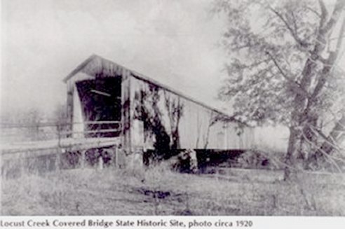
On August 4,
1868, the Linn County Commissioners awarded a contract to the
firm of Bishop & Eaton for construction of a covered bridge
at a cost "not to exceed $5,000." The 151 foot
structure, orignally known as the linn County Bridge, was
completed and opened to traffic the same year. It is the longest
of the four surviving covered bridges in the state.
The bridge was
built with the Howe-truss system and features arched entrances
with ramps sloping away from both ends. It was situated on the
main east-west road in northern Missouri, running parallel to
the Hannibal and St. Joseph Railroad. Midway between Laclede and
Meadville, Locust Creek Covered Bridge served a local population
that included the young John Joseph Pershing, who became the
nation's highest ranking military commander. As a boy, Pershing
swam and fished in the creek near the bridge.
The road on
which the bridge was located later became Route 8, the nation's
first transcontinental highway. Locust Creek's channel was
altered following World War II, leaving the bridge spanning a
dry creek bed, and Us. Highway 36 replaced Route 8 as the main
traffice artery across northern Missouri. By 1960, the county
ahd ceased maintaining of the west access road, and the bridge
became virtually inaccessible. The state of Missouri received
title to the bridge in 1968 and designated it a state historic
site. Two years later it was placed on the National Register of
Historic Places.
|